
Commons:Graphic Lab/Map workshop
| Illustration Workshop | Map Workshop | Photography Workshop | Video and Sound Workshop |
 Map workshop
This workshop is part of the Graphic Lab, a project aimed at picture retouching to improve the graphical content of the Wikimedia projects. More information about the lab can be found on its main page and requests pages (Illustrations ; Photographs ; Maps ; Video and Sound). To ask questions or make a suggestions, see the talk page of the graphic lab page.
This specific page is the requests page for the Map Workshop. Anyone can make a request for a map to be created or improved. The standard format for making a request is shown below, along with general advice, and should be followed. Most maps on the web are in the public domain. See Template:PD-map; no need to create another free map here if it already exists on the web.
Make a request
Use the following template when making a new request, replacing the examples with your image(s) and request(s):
<gallery>
 IMAGENAME.EXT|Description of image
 IMAGE#TWO.EXT|2nd image (If there is one)
 ETCETCETC.EXT|Don't request too many at once, though
</gallery>

;Request:
: Details of your request go here… --~~~~
;Graphist opinion(s):
See also
[edit] |
SpBot archives all sections tagged with {{Section resolved|1=~~~~}} after 7 days and sections whose most recent comment is older than 185 days. For the archive overview, see /Archive. The latest archive is located at /Archive/2026. |
Update and vectorize biomes of Turkey
[edit]-
 source
 -
 crop
crop -
 version by LápizRoto


I used an online tool to crop but I could not figure out how to save it as svg
Article(s): en:List of ecoregions in Turkey and others
- Request
- I looked in “Category:Biome maps” but I could not find anything. I would like to add the names of the biomes so they can be translated.
Could you possibly update per [1][2]? --Chidgk1 (talk) 11:12, 10 March 2025 (UTC)
- Graphist opinion(s)
- Chidgk1, please take a look. I got the names of the biomes directly from the source SVG (I also tried your links, but they were confusing and didn't seem to align exactly with the source details). If you would like me to make any other changes, just let me know exactly what you need. Or if you're happy with the result, let me know too. LápizRoto (talk) 06:35, 28 June 2025 (UTC)
- @LápizRoto Sorry for extremely late reply - for some reason I only just noticed you had done this. Thank you very much. I especially like the well-placed legend box.
- I see that @Terpsichores created Western palearctic biomes.svg in 2012 based on WWF data. I understand that WWF later passed the responsibility for maintaining such data to One Earth hence my links. So I think the reason for the non-alignment you mention is that the biomes have been updated since 2012. For our map to be up to date, if possible I would like the One Earth maps to be used and cited as our source not WWF.
- Also the One Earth maps look better as they have fewer lines. Would it be possible for you to update per One Earth? If you need me to contact them via https://www.oneearth.org/contactus/ please let me know. Chidgk1 (talk) 07:07, 11 September 2025 (UTC)
- ↑ Western Eurasia | Realm & Subrealms (English). One Earth (2025-03-07). Retrieved on 2025-03-10.
- ↑ Central Eurasia | Realm & Subrealms (English). One Earth (2025-03-07). Retrieved on 2025-03-10.
Map is unmaintainable by editors who might wish to correct details
[edit].png)

Article(s): wikipedia:en:Law#Legal_systems
- Request
- Are there any frameworks or tools that could replace this file with a version that maintains the high graphical quality of the original, but permits granular editing (for example of facts like changing political boundaries, or developments in the subject matter, or corrections resulting from sourcing errors)? TheFeds 21:56, 12 March 2025 (UTC)
- Graphist opinion(s)
- @TheFeds: Not sure what you mean? Are you struggling with editing SVG files, in such case you can use Inkscape. BorysMapping (talk) 10:15, 9 July 2025 (UTC)
- My concept was that this map had been created with a tool or framework of some sort, which queried and generated the political boundaries, the table and graph styles, etc., and allowed the user to not resort to manually drawing vectors in Inkscape. Without the practical ability to correct small errors, the images will gradually become less usable in Wikipedia articles, and might have to be editorially omitted or couched with limiting statements. TheFeds 20:27, 20 October 2025 (UTC)
- @TheFeds I have downloaded, open and edited both files and there is not any difficulties with that;
- svg file with Inkscape, as was mentioned before
- png file with Gimp
- the svg file as to be uploaded by a autoconfirmed user, or you can ask at Commons:Village_pump
- If this is not what you mean you have to explain in another way. --please ping me-- Goran tek-en (talk) 15:10, 21 December 2025 (UTC)
- @Goran tek-en: I was attempting to use this as example to ask a broader question about how to keep maps with legends up to date, without having to raster edit a PNG, or use the SVG that appears to be an incomplete copy. I was hoping that someone had found or made a tool that takes scripted input like some form of markup, and lets a modified derivative version be made without necessarily being an accomplished image editor. As the image gets older, present reality may diverge from what is depicted, and (mainly) Wikipedia editors will have to decide whether to live with a 95% correct image in the article, or remove the image because it is 5% incorrect. If things like the base map (e.g. for boundaries and projection), colours, labels, overlays, etc. were in conveniently structured layers that could be individually edited, that might make such a task easier. I know that in an SVG editor, the individual path entities are editable, but this is both difficult and complicated for the average user. Maybe @Goldsztern (the SVG image's creator) was attempting a preliminary version of this, by creating a native vector version (they cited the base map and the data sources) that could at least be edited carefully in the future. I was hoping there might be a more advanced version somewhere that allowed a user without technical skill or a lot of time to see which fact corresponded to which vector object, and to change the characteristics. TheFeds 07:07, 22 December 2025 (UTC)
- @TheFeds Thanks for explaining.
- If we had a perfect world and everyone did everything in exact the same way maybe, maybe this would be possible. But here at commons (wikimedia) with so many different people involved I say, no way.
- It's messy and we will always be behind with edits just like all books, educations etc are. --please ping me-- Goran tek-en (talk) 17:20, 22 December 2025 (UTC)
- @Goran tek-en: I was attempting to use this as example to ask a broader question about how to keep maps with legends up to date, without having to raster edit a PNG, or use the SVG that appears to be an incomplete copy. I was hoping that someone had found or made a tool that takes scripted input like some form of markup, and lets a modified derivative version be made without necessarily being an accomplished image editor. As the image gets older, present reality may diverge from what is depicted, and (mainly) Wikipedia editors will have to decide whether to live with a 95% correct image in the article, or remove the image because it is 5% incorrect. If things like the base map (e.g. for boundaries and projection), colours, labels, overlays, etc. were in conveniently structured layers that could be individually edited, that might make such a task easier. I know that in an SVG editor, the individual path entities are editable, but this is both difficult and complicated for the average user. Maybe @Goldsztern (the SVG image's creator) was attempting a preliminary version of this, by creating a native vector version (they cited the base map and the data sources) that could at least be edited carefully in the future. I was hoping there might be a more advanced version somewhere that allowed a user without technical skill or a lot of time to see which fact corresponded to which vector object, and to change the characteristics. TheFeds 07:07, 22 December 2025 (UTC)
- @TheFeds I have downloaded, open and edited both files and there is not any difficulties with that;
Degoogling of funicular derailment map
[edit]-

 Done
Done

Article(s): 2025 Ascensor da Glória derailment (Q136090574)
- Request
- I request that this map published by the Portuguese public agency GPIAAF be traced over using OpenStreetMap (or another free alternative) and vectorised. it likely fails as copyvio, however, passing it through here before submitting it to deletion. --Juwan (talk) 23:35, 9 September 2025 (UTC)
- Graphist opinion(s)
 Request taken by cmglee: Failing to find any free aerial photographs showing the route, I'll use OSM. cmɢʟee ⋅τaʟκ 10:02, 10 September 2025 (UTC)
- Done @Juwan: File:Gloria_funicular_accident_map.svg is ready for translation into other languages. cmɢʟee ⋅τaʟκ 17:21, 10 September 2025 (UTC)
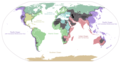
File:Threshold of originality world map.svg content issue
[edit]-
 Problematic content: Crimea, Ukraine, Russia

- Request
- Please fix the colour shading of the en:Crimea part. Since the map's inception, it's in the shade given to Russia, but that's politically wrong. Virtually no state body outside of Russia's supporters recognise en:Crimea as legitimate part of Russia, despite its annexion claims. It must be in the shade given to en:Ukraine. Thanks! Regards, Grand-Duc (talk) 05:23, 9 October 2025 (UTC)
- Graphist opinion(s)
- @Grand-Duc: But this map has nothing to do with politics to my understanding.
![]() Done --please ping me-- Goran tek-en (talk) 13:34, 19 October 2025 (UTC)
Done --please ping me-- Goran tek-en (talk) 13:34, 19 October 2025 (UTC)
Confusing map
[edit]-
 Distribution map of Budgerigar

Article(s): Category:Melopsittacus undulatus (distribution maps) and elsewhere
- Request
- The dark blue (indicating the temperate zone) is much too dark, making it look like the main objective of the map (i.e., where Budgerigars occur), rather than just another climate zone. Please make it a much paler shade, comparable to the other climate zones in colour intensity (I don't have svg-editing software so can't do this myself). I'd suggest #80eecc for the new colour. Once done, I'll undertake to edit the keys on all the wikipedia pages the map is used on to clarify the new colour. - MPF (talk) 16:17, 19 October 2025 (UTC)
- Graphist opinion(s)
- I updated the SVG image. You may have to flush some browser caches to see it. Thank you for suggesting a specific color, and one that doesn't look like it is trying to indicate water. – b_jonas 11:01, 24 October 2025 (UTC)
- That's superb, thanks! - MPF (talk) 21:05, 24 October 2025 (UTC)
SVG separatist world map
[edit]-
 World map with all successful movements
 -
SVG

Article(s): جداییخواهی
- Request
- I request an SVG version of this simple world map. --ANOTHERWlKlPEDlAN wɑit thɑt’s ɑ typo 23:08, 12 November 2025 (UTC)
- Graphist opinion(s)
File:South Korea Postcode Map.svg transparency flattening request
[edit]-
 The file

Article(s): en:Postal codes in South Korea, ko:대한민국의 우편번호, ko:국가기초구역번호
- Request
- Hello! This file was originally a 'fake vector' file embedding a raster image. When vectorization was performed, the MediaWiki extension failed to render it properly and caused a 429 error. So I reverted it to the 'false vector' version. The true vector version, dated at 14:26, 29 November 2025, used multiple layers and transparent filters for coloring, I guess that's why the rendering has failed. Could someone please flatten the transparency (convert transparent overlaps into solid colors) and clean up the file so it renders correctly? I tried to do it myself but failed. Thanks!--起司狗 (talk) 07:44, 30 November 2025 (UTC)
- Graphist opinion(s)
Request: File:State positions Iraq war.svg Please correct the missing content in this map.
[edit]-
 See request below.

Article(s): Iraq–European Union relations#Divisions in the approach to 2003 Iraq war, International reactions to the prelude to the Iraq War and Legality of the Iraq War
- Request
- I found that there were some missing in this map. Six countries including Luxembourg, the Republic of Ireland, Cyprus, Armenia, Burma and Cambodia, together with Greece, France, Greece, Russia, China, Vietnam and other countries, opposing the Iraq War. I suggest changing the colors of the six countries including Luxembourg, the Republic of Ireland, Cyprus, Armenia, Burma and Cambodia to the same blue color as those of Germany, France, Greece, Russia, China and Vietnam. Thanks. At the same time, Ukraine should be changed to gray, and the Solomon Islands and Rwanda should be changed to yellow like Japan. Other contents remain unchanged. --Boston Mayflower (talk) 07:41, 7 December 2025 (UTC)
- @Milenioscuro Please look here, thank you very much. Boston Mayflower (talk) 14:09, 18 January 2026 (UTC)
![]() Done --Milenioscuro (talk) 19:54, 18 January 2026 (UTC)
Done --Milenioscuro (talk) 19:54, 18 January 2026 (UTC)
- @Milenioscuro Additionally East Timor should be changed to gray and Vatican City, Liechtenstein should be changed to blue. The then Pope John Paul II clearly opposed the Iraq War and Liechtenstein maintains a high degree of consistency with Switzerland and Austria in defense and foreign policies, but East Timor has not yet made clear its attitude towards the Iraq War and is considered neutral for the time being. Also before 2006, Serbia and Montenegro were one country instead of two countries, but the bug in this SVG code has not been corrected, and the border between Serbia and Montenegro is still clearly visible. As in the 2003 map, this bug should be corrected and Serbia and Montenegro merged into one country, but the color is still blue. thanks. Boston Mayflower (talk) 21:31, 19 January 2026 (UTC)
- @Milenioscuro Please see my new reply, thank you very much. Boston Mayflower (talk) 06:47, 21 January 2026 (UTC)
Improve history map (India - History- South Asia)
[edit]-
 Map of Chera kingdom, southern India
 -
.jpg/120px-Chera_country_(early_historic_south_India).jpg) Map of Chera kingdom, southern India
Map of Chera kingdom, southern India

.jpg)
Article(s): en:Chera dynasty
- Request
- Can someone please adjust the geographical extent of the Chera country in the first map to match the second map, which represents the correct (more accurate) extent? --JamesMdp (talk) 14:06, 29 December 2025 (UTC)
- Graphist opinion(s)
 Done in the grey-green globe scheme
- @JamesMdp: File:Chera_kingdom,_southern_India.png is a PNG image and should be recreated as an SVG, perhaps with a different projection. Request taken by cmɢʟee ⋅τaʟκ 03:30, 2 January 2026 (UTC)
Somaliland is missing from the map
[edit]-
 Countries with diplomatic relations with Israel

Article(s): en:Foreign relations of Israel
- Request
- Could someone please add Somaliland? --Regioncalifornia (talk) 21:53, 29 December 2025 (UTC)
- Graphist opinion(s)
- Somalia is drawn as a single path (with id="so"). To satisfy the request, Somaliland has to be split out from this path. cmɢʟee ⋅τaʟκ 01:09, 31 December 2025 (UTC)
![]() Done--Mike Rohsopht (talk) 06:09, 7 March 2026 (UTC)
Done--Mike Rohsopht (talk) 06:09, 7 March 2026 (UTC)
Remove Somaliland from the maps
[edit]-
 International recognition of the State of Palestine
 -
 Diplomatic relations of State of Palestine


Article(s): en:International recognition of Palestine; en:Foreign relations of Palestine
- Request
- Somaliland does not officially recognize the State of Palestine, and the State of Palestine absolutely rejects Somaliland's existence and independence. They do not have diplomatic relations, so I am requesting that someone please remove Somaliland from both maps. Thank you. --Regioncalifornia (talk) 17:19, 30 December 2025 (UTC)
- Graphist opinion(s)
- As of now, only one country recognises Somaliland. Whereas File:Israel-somaliland_locator.svg is specifically about that topic, these maps are about a third country. Is it premature to update them when most countries still consider Somalia a single country? It's opening a can of worms to have to continually update this and other maps when separatists have different stands from their respective countries. cmɢʟee ⋅τaʟκ 01:19, 31 December 2025 (UTC)
Vectorise Cairo Rapid Transit map.png for translation
[edit]-
 Current: File:Cairo Rapid Transit map.png

Article(s): en:Cairo Metro, fr:Métro du Caire, ja:カイロ地下鉄, etc
- Request
- Create an SVG version of File:Cairo Rapid Transit map.png ready for translation. I am not sure if potential rtl need to be sorted in the svg. User:AAEexecutive has a partially completed English google-translated png: File:Cairo_Rapid_Transit_map_(English).png. --Commander Keane (talk) 03:12, 14 January 2026 (UTC)
- Graphist opinion(s)
Blank SVG map of Europe in 1648
[edit]-
 Blank SVG map of Europe in 1714
 -
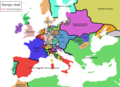 PNG map of Europe in 1648
 -
 SVG map of the HRE in 1648
 -
 SVG map of Ottoman expansion in the 16th and 17th centuries
 -
 SVG map of the Polish-Lithuanian Commonwealth in 1648
 -
 Locator SVG map of the Zaporizhian Host in 1649
 -
 SVG map of the kingdoms of Spain before 1700


- Request
- Lately I've been very impressed by the work of Alphathon (talk · contribs) and other users on the Historical Europe series, but I recently noticed that the furthest back it goes in the modern era is 1714, so I was hoping someone here would be able to create one showing the aftermath of the Westphalia peace in 1648. Judging by the maps we have of Europe in 1648, it seems like the main changes from the 1714 map would be: the border between the HRE and France, particularly with respect to the region of Franche-Comté and the Spanish Netherlands; the border between the Habsburg monarchy and the Ottoman Empire, particularly Hungary and Transylvania; the border between Poland-Lithuania, the Ottoman Empire and Russia, particularly the Cossack Hetmanate; the internal borders of Habsburg Spain, showing the Crowns of Castile and Aragon; the internal borders of Britain, showing Scotland and England. I've added as many svg files to this post as I could find that might help with construction. I understand this is a relatively big task, so any help would be very much appreciated. --Grnrchst (talk) 15:04, 15 January 2026 (UTC)
- Graphist opinion(s)
- Request taken by --please ping me-- Goran tek-en (talk) 13:54, 5 February 2026 (UTC)
- @Grnrchst: As I have no knowledge of this I will need your help for this work. The sources don't have to be svg, bitmap is fine. --please ping me-- Goran tek-en (talk) 13:54, 5 February 2026 (UTC)
- @Goran tek-en: Happy to help however I can. Let me know what you may need. --Grnrchst (talk) 14:04, 5 February 2026 (UTC)
- @Grnrchst
- From this map File:Holy_Roman_Empire_1648.svg, which parts do you want (from the legend)?
- Should I keep the dashed black line and all the smaller areas within it from this File:Blank_map_of_Europe_1714.svg?
- When you use different maps like this they will never fit exactly so adapt stuff, just so you know.
- --please ping me-- Goran tek-en (talk) 15:09, 6 February 2026 (UTC)
- @Goran tek-en: As far as I can tell, the main changes would be the border of the Spanish Netherlands and Franche-Comte. The black dashed line should be kept but altered to accomodate for those two areas; the smaller areas within the HRE won't need any changing, as far as I'm aware (comparing the two maps, these two parts seem to be the only changes). Thanks. --Grnrchst (talk) 15:21, 6 February 2026 (UTC)
- @Grnrchst As I did say before, the different maps don't match each other so I have to adjust.
- To me there are many more changes and I don't really know what to do.
- A part from the HRE map
- Roughly same part in the svg I'm working in. Black lines is the red in HRE.
- As you can see there are differences and right now I don't know what to remove or adjust, really hard.
- I will have to think a bit about this, what do you think, you have the knowledge of changes here? --please ping me-- Goran tek-en (talk) 18:57, 6 February 2026 (UTC)
- @Grnrchst
- ----
- Those drafts are PNG versions of the original SVG file I'm working in and will upload to commons.
- Those drafts are shown for proofreading only.
- ----
- Now I have Draft 1648-1 in which I have added the HRE part. I removed everything within HRE in 1714 map and then adde from 1648 map.
- I might have missed something so really check and give me feedback, thanks. --please ping me-- Goran tek-en (talk) 15:31, 7 February 2026 (UTC)
- @Goran tek-en: A couple of things I noticed in the draft: there seems to be a hole in the middle of the Kingdom of Bohemia that wasn't there in the original map; western Pomerania should be inside the dotted line. I'll keep looking to see if there's anything else. Thanks again. --Grnrchst (talk) 16:16, 7 February 2026 (UTC)
- @Grnrchst Draft 1648-2 --please ping me-- Goran tek-en (talk) 12:46, 8 February 2026 (UTC)
- @Grnrchst Don't want to rush you, just inform you that I need your feedback on my draft's before I continue, thanks. --please ping me-- Goran tek-en (talk) 14:12, 9 February 2026 (UTC)
- @Goran tek-en: No worries, thanks for the ping. As far as I can see, the internal borders of the Holy Roman Empire all seem to align with the 1648 map of the HRE. Great work on this so far! --Grnrchst (talk) 14:18, 9 February 2026 (UTC)
- @Grnrchst
- Draft 1648-3, Ottoman part.
- Brown lines are from the Ottoman map, previous white lines removed.
- The thin yellow area is a part I don't understand. The Ottoman area doesn't reach all the way to the HRE area. It might just be different map mistakes but I hope you know.
- --please ping me-- Goran tek-en (talk) 11:33, 10 February 2026 (UTC)
- @Goran tek-en: That yellow area was part of the Habsburg monarchy and encompassed areas of the Kingdom of Hungary outside the HRE (the Habsburgs held land both inside and outside the HRE). --Grnrchst (talk) 11:36, 10 February 2026 (UTC)
- @Grnrchst You are so quick.
- So the brown lines (will be white) are correct like this? --please ping me-- Goran tek-en (talk) 12:13, 10 February 2026 (UTC)
- @Goran tek-en: There's a couple issues, as Podolia was not annexed from Poland-Lithuania until 1672 and the cities of Nitra (Neutra) and Oradea (Grosswardein) were not annexed from the Habsburgs until 1664. --Grnrchst (talk) 12:19, 10 February 2026 (UTC)
- @Grnrchst So should I
- remove the border of Podolia
- make borders (hole) for the two cities?
- Please just tell me what to do directly. --please ping me-- Goran tek-en (talk) 15:37, 10 February 2026 (UTC)
- @Goran tek-en: Remove the border for Podolia; for the cities, Neutra should be within the borders of the Kingdom of Hungary and Grosswardein should be within the borders of the Principality of Transylvania. --Grnrchst (talk) 15:45, 10 February 2026 (UTC)
- Oh I also just noticed Brăila (small bit east of Wallachia) and Budjak (small bit south of Yedisan), which should both be within the borders of the Ottoman Empire. --Grnrchst (talk) 15:59, 10 February 2026 (UTC)
- @Grnrchst
- The cities, to me they were inside KoH and PoT. So maybe you meant to remove the small areas of 1664. If so please be specific what to edit/remove. I don't have any knowledge of the subject, to me it's more or less just lines.
- We don't have a specific border for the OE so it's the same here. I removed the small areas.
- So check the draft below and tell me what to edit, thanks.
- Draft 1648-4
- --please ping me-- Goran tek-en (talk) 11:19, 11 February 2026 (UTC)
- @Goran tek-en: Remove the wee circles in Hungary and Transylvania. Other than that, this part of the map looks good! Thanks again. --Grnrchst (talk) 11:30, 11 February 2026 (UTC)
- @Grnrchst I got sick so it will be some day's before I'm back. --please ping me-- Goran tek-en (talk) 12:56, 13 February 2026 (UTC)
- @Goran tek-en: No bother. Take all the time you need, I hope you feel better soon! :) --Grnrchst (talk) 13:15, 13 February 2026 (UTC)
- @Grnrchst
- I have removed the circles, check all.
- Draft 1648-5.
- Roughly within the red line.
- What should I do with the borders that just ends in nothing?
- --please ping me-- Goran tek-en (talk) 15:21, 18 February 2026 (UTC)
- @Goran tek-en: I think the smaller endless borders can be removed. The main things to focus on with the internal borders of Poland-Lithuania are the principal polities of: the Kingdom of Poland, the Grand Duchy of Lithuania, the Duchy of Prussia, the Duchy of Courland, Livonia, and the Cossack Hetmanate. --Grnrchst (talk) 15:30, 18 February 2026 (UTC)
- @Grnrchst
- @Goran tek-en: No bother. Take all the time you need, I hope you feel better soon! :) --Grnrchst (talk) 13:15, 13 February 2026 (UTC)
- @Grnrchst I got sick so it will be some day's before I'm back. --please ping me-- Goran tek-en (talk) 12:56, 13 February 2026 (UTC)
- @Goran tek-en: Remove the wee circles in Hungary and Transylvania. Other than that, this part of the map looks good! Thanks again. --Grnrchst (talk) 11:30, 11 February 2026 (UTC)
- @Grnrchst
- @Grnrchst So should I
- @Goran tek-en: That yellow area was part of the Habsburg monarchy and encompassed areas of the Kingdom of Hungary outside the HRE (the Habsburgs held land both inside and outside the HRE). --Grnrchst (talk) 11:36, 10 February 2026 (UTC)
- @Goran tek-en: No worries, thanks for the ping. As far as I can see, the internal borders of the Holy Roman Empire all seem to align with the 1648 map of the HRE. Great work on this so far! --Grnrchst (talk) 14:18, 9 February 2026 (UTC)
- @Grnrchst Don't want to rush you, just inform you that I need your feedback on my draft's before I continue, thanks. --please ping me-- Goran tek-en (talk) 14:12, 9 February 2026 (UTC)
- @Grnrchst Draft 1648-2 --please ping me-- Goran tek-en (talk) 12:46, 8 February 2026 (UTC)
- @Goran tek-en: A couple of things I noticed in the draft: there seems to be a hole in the middle of the Kingdom of Bohemia that wasn't there in the original map; western Pomerania should be inside the dotted line. I'll keep looking to see if there's anything else. Thanks again. --Grnrchst (talk) 16:16, 7 February 2026 (UTC)
- @Grnrchst As I did say before, the different maps don't match each other so I have to adjust.
- @Goran tek-en: As far as I can tell, the main changes would be the border of the Spanish Netherlands and Franche-Comte. The black dashed line should be kept but altered to accomodate for those two areas; the smaller areas within the HRE won't need any changing, as far as I'm aware (comparing the two maps, these two parts seem to be the only changes). Thanks. --Grnrchst (talk) 15:21, 6 February 2026 (UTC)
- @Grnrchst
- @Goran tek-en: Happy to help however I can. Let me know what you may need. --Grnrchst (talk) 14:04, 5 February 2026 (UTC)
- @Grnrchst: As I have no knowledge of this I will need your help for this work. The sources don't have to be svg, bitmap is fine. --please ping me-- Goran tek-en (talk) 13:54, 5 February 2026 (UTC)
- @Grnrchst:
- How should I know which area is which from those names? --please ping me-- Goran tek-en (talk) 16:57, 19 February 2026 (UTC)
- Right, sorry. In this map: the Duchy of Courland (in modern-day Latvia) and Duchy of Prussia are shaded in grey and yellow; the area to the north of Courland is Livonia; the Cossack Hetmanate consists of the three regions of Kiev, Breslov and Chernigov; everything inside the thick gray line as well as Smolensk are in the Grand Duchy of Lithuania; and everything else (west and south of Prussia and Lithuania, and west of the Hetmanate) is in the Kingdom of Poland. --Grnrchst (talk) 17:10, 19 February 2026 (UTC)
- @Grnrchst
- The colored areas is just so you can see if I understood you correct, will be replaced with grey.
- The darkgreen areas is something I don't understand.
- The border lines that end in nothing all end up to a river, could it mean the river is the border then?
- Cossack Hetmanate, can't find a border towards Smolensk so I have guessed
- Draft 1648-6 --please ping me-- Goran tek-en (talk) 14:53, 22 February 2026 (UTC)
- @Goran tek-en: Coloured areas all look good. By this time, the dark green area to the west was part of Courland; the dark green areas to the east were de facto under Swedish control but weren't formally ceded by Poland-Lithuania until 1660 (I think it would probably be best to put them within the Swedish empire, perhaps with a dotted line, to show de facto control). And yes, the Cossack Hetmanate border near Smolensk looks correct! --Grnrchst (talk) 10:33, 23 February 2026 (UTC)
- @Grnrchst Draft 1648-7, like this? --please ping me-- Goran tek-en (talk) 13:05, 24 February 2026 (UTC)
- @Goran tek-en: Yes, that looks good! --Grnrchst (talk) 13:08, 24 February 2026 (UTC)
- @Grnrchst Spanish part, Draft 1648-8, red lines but white when correct. --please ping me-- Goran tek-en (talk) 13:46, 24 February 2026 (UTC)
- @Goran tek-en: By this time, the Kingdom of Grenada was part of the Crown of Castile, so it should also have a thin dotted line rather than a thick one. All else looks good in Spain. --Grnrchst (talk) 13:52, 24 February 2026 (UTC)
- @Grnrchst
- Draft 1648-9
- What else? --please ping me-- Goran tek-en (talk) 14:00, 25 February 2026 (UTC)
- @Goran tek-en: Is there a reason the Grand Duchy of Lithuania and the Kingdom of Poland (coloured parts in draft 6) are still broken up by their internal borders in this one? Apologies if I've not been clear enough on that. Other than that, there needs to be a border between Scotland and England; the border between Sweden and Denmark-Norway would need adjusting (per this map); changes need to be made to the borders between Piedmont, Milan and Mantua (per this map); and the border of the Crimean Khanate needs to be drawn. Grnrchst (talk) 14:39, 25 February 2026 (UTC)
- @Grnrchst
- Sorry I don't keep the previous drafts so you have to more specific, and/or refer to the source for that area.
- I don't understand where Mantua is located.
- Crimean Khanate, it's a compicated map for me with several different time periods. The dashed red is from your source (added a bit down right).
- Should I keep those and adjust the white borders?
- Draft 1648-10 --please ping me-- Goran tek-en (talk) 12:04, 26 February 2026 (UTC)
- @Goran tek-en: Per this map, Lithuania should be the provinces inside the thick line (Samogitia, Vilna, Trakai, Brest-Litovsk, Nowogrodek, Minsk, Mstsislaw, Vitebsk, Polotsk and Smolensk); and Poland should be the remaining provinces (Rutenia, Volinia, Belz, Lublin, Cracovia, Sandomir, Sieradz, Rawa, Mazovia, Leczyca, Kalisz, Plock, Bresc Kujawski, Poznan, Inowroclaw, Pomerania and Mariemburgo).
- Northern Italy's looking good now (Mantua was that small state south of Venice and east of Milan). The borders of the Crimea Khanate were more concentrated around the sea of Azov at that time, see this map and this map. --Grnrchst (talk) 15:43, 26 February 2026 (UTC)
- @Grnrchst
- The thin colored lines are from the sources and will be removed.
- Draft 1648-11 --please ping me-- Goran tek-en (talk) 13:59, 27 February 2026 (UTC)
- @Goran tek-en: If I'm understanding this right, would this remove the borders between Prussia and Poland and between Courland and Lithuania? Other than those queries, this all looks good. --Grnrchst (talk) 14:07, 27 February 2026 (UTC)
- @Grnrchst
- I believe they are here but check.
- I have added the rivers (soft) that connect or pass a borders, if you dont want them just tell me.
- Draft 1648-12 --please ping me-- Goran tek-en (talk) 15:55, 1 March 2026 (UTC)
- @Goran tek-en: No to the rivers, as rivers aren't shown anywhere else. --Grnrchst (talk) 09:04, 2 March 2026 (UTC)
- @Grnrchst And the rest? --please ping me-- Goran tek-en (talk) 15:10, 2 March 2026 (UTC)
- @Goran tek-en: Figured I just do a mock-up, here's roughly what it should look like. --Grnrchst (talk) 17:53, 3 March 2026 (UTC)
- @Grnrchst Thanks for that image, it helps a lot.
- Draft 1648-13 --please ping me-- Goran tek-en (talk) 10:44, 5 March 2026 (UTC)
- @Goran tek-en: Amazing work, this looks great. As far as I can tell, this is good to go. The only other suggestion I'd have would be to possibly put a thick dotted line (similar to HRE) around other composite states, mainly the Spanish kingdoms (red parts on this map) and the Polish-Lithuanian commonwealth, but I'm not sure this is entirely necessary. --Grnrchst (talk) 13:56, 5 March 2026 (UTC)
- @Grnrchst
- That would look like this Draft 1648-14
- When we are done I will need the following;
- Name of the file
- Description (/language)
- Captions/s (/language)
- Category/ies at commons
- Structured data/Items portrayed in this file, the Q#, to be able to upload it at commons, thanks.
- --please ping me-- Goran tek-en (talk) 13:56, 6 March 2026 (UTC)
- @Goran tek-en: Looks great!
- Name: Europe 1648.svg
- Description: A political map of Europe circa 1648, including external borders for the Holy Roman Empire, the Hispanic Monarchy and the Polish-Lithuanian Commonwealth.
- Caption: Political map of Europe, 1648
- Categories: Category:1648 maps of Europe; Category:Blank maps of Early Modern period Europe; Category:Blank SVG maps of Europe for historical use; Category:Maps of territorial evolution of Europe.
- I have no idea what would go in the structured data for a map like this to be honest. --Grnrchst (talk) 14:35, 6 March 2026 (UTC)
- @Grnrchst Now you can find it here Europe 1648.
- Please check all the information, also links for wikipedia, wikidata and structured data.
- If you are happy with this please put the code
"{{section re.solved|1=~~~~}}"(without the ".") on this request so it can be archived, thanks.
- Done --please ping me-- Goran tek-en (talk) 16:32, 6 March 2026 (UTC)
- @Grnrchst Now you can find it here Europe 1648.
- @Goran tek-en: Looks great!
- @Goran tek-en: Amazing work, this looks great. As far as I can tell, this is good to go. The only other suggestion I'd have would be to possibly put a thick dotted line (similar to HRE) around other composite states, mainly the Spanish kingdoms (red parts on this map) and the Polish-Lithuanian commonwealth, but I'm not sure this is entirely necessary. --Grnrchst (talk) 13:56, 5 March 2026 (UTC)
- @Goran tek-en: Figured I just do a mock-up, here's roughly what it should look like. --Grnrchst (talk) 17:53, 3 March 2026 (UTC)
- @Grnrchst And the rest? --please ping me-- Goran tek-en (talk) 15:10, 2 March 2026 (UTC)
- @Goran tek-en: No to the rivers, as rivers aren't shown anywhere else. --Grnrchst (talk) 09:04, 2 March 2026 (UTC)
- @Goran tek-en: If I'm understanding this right, would this remove the borders between Prussia and Poland and between Courland and Lithuania? Other than those queries, this all looks good. --Grnrchst (talk) 14:07, 27 February 2026 (UTC)
- @Grnrchst
- @Grnrchst
- @Goran tek-en: Is there a reason the Grand Duchy of Lithuania and the Kingdom of Poland (coloured parts in draft 6) are still broken up by their internal borders in this one? Apologies if I've not been clear enough on that. Other than that, there needs to be a border between Scotland and England; the border between Sweden and Denmark-Norway would need adjusting (per this map); changes need to be made to the borders between Piedmont, Milan and Mantua (per this map); and the border of the Crimean Khanate needs to be drawn. Grnrchst (talk) 14:39, 25 February 2026 (UTC)
- @Goran tek-en: By this time, the Kingdom of Grenada was part of the Crown of Castile, so it should also have a thin dotted line rather than a thick one. All else looks good in Spain. --Grnrchst (talk) 13:52, 24 February 2026 (UTC)
- @Grnrchst Spanish part, Draft 1648-8, red lines but white when correct. --please ping me-- Goran tek-en (talk) 13:46, 24 February 2026 (UTC)
- @Goran tek-en: Yes, that looks good! --Grnrchst (talk) 13:08, 24 February 2026 (UTC)
- @Grnrchst Draft 1648-7, like this? --please ping me-- Goran tek-en (talk) 13:05, 24 February 2026 (UTC)
- @Goran tek-en: Coloured areas all look good. By this time, the dark green area to the west was part of Courland; the dark green areas to the east were de facto under Swedish control but weren't formally ceded by Poland-Lithuania until 1660 (I think it would probably be best to put them within the Swedish empire, perhaps with a dotted line, to show de facto control). And yes, the Cossack Hetmanate border near Smolensk looks correct! --Grnrchst (talk) 10:33, 23 February 2026 (UTC)
- @Grnrchst
- Right, sorry. In this map: the Duchy of Courland (in modern-day Latvia) and Duchy of Prussia are shaded in grey and yellow; the area to the north of Courland is Livonia; the Cossack Hetmanate consists of the three regions of Kiev, Breslov and Chernigov; everything inside the thick gray line as well as Smolensk are in the Grand Duchy of Lithuania; and everything else (west and south of Prussia and Lithuania, and west of the Hetmanate) is in the Kingdom of Poland. --Grnrchst (talk) 17:10, 19 February 2026 (UTC)
- @Goran tek-en: Ach, sorry, I was hoping to close this thread but I just tried to use the file and the way the paths are set is making it really tricky to edit. With these kinds of maps, it's important for each path that encloses a state or territory be unified, otherwise attempting to fill in the map becomes exceedingly difficult. As an example, see the way the paths are set in File:Europe 1789.svg and how I used them to colour File:Absolutism in Europe 1789.svg. --Grnrchst (talk) 17:54, 6 March 2026 (UTC)
- @Grnrchst I didn't know this uphand, also I don't exactly understand what you mean by "unified", is it "close".
- Do you also want each area to have both the grey fill and white line?
- The black dashed lines should be just lines no fill? --please ping me-- Goran tek-en (talk) 18:01, 6 March 2026 (UTC)
- @Goran tek-en: Yes, that's correct. Each area should be both grey fills and white lines; black dash lines should be lines but no fill. Really sorry for not communicating this upfront, I'm still new to svg editing and hadn't considered this part. --Grnrchst (talk) 18:03, 6 March 2026 (UTC)
- @Grnrchst No worries, do in the next days. --please ping me-- Goran tek-en (talk) 18:04, 6 March 2026 (UTC)
- @Grnrchst There is an effect when you have two dashed white lines above each other. Each line counts by it self where the dashes starts so it gets a bit strange. Also when you have a dashed and a full line above each other (with the area filled) you can get strange stuff depending on which area/line is above the other one.
- I have looked at File:Absolutism in Europe 1789.svg and it looks like you always keep the white lines as they are.
- Is it really just the area that you are coloring and never the line?
- If so, I suggest that where the above appears we have each filled area separat and the lines (just lines) above so I can cut them to avoid the above.
- So in those areas you will have to color the filled area by itself, and place it below the lines.
- I don't know what tool you use to change the color but I hope it's Inkscape (or similar).
- Tell me if this will work for you, thanks.
- --please ping me-- Goran tek-en (talk) 15:17, 8 March 2026 (UTC)
- @Goran tek-en: Yes, it's the area being coloured, not the line. What you propose for the areas seems to make sense. And yes, I'm using Inkscape for svg editing; with Inkscape I can simply select an area by clicking on it and fill it. --Grnrchst (talk) 21:54, 8 March 2026 (UTC)
- @Grnrchst This is a bit complicated so it will take a while, I started another map when we thought this was done. I will work on this but I have to spend some time with other stuff as well so it might take a while, I will not forget, thanks for your patience. Just ping me if you think I have been quite too long. --please ping me-- Goran tek-en (talk) 16:00, 9 March 2026 (UTC)
- @Goran tek-en: No worries at all, take all the time you need. Thank you for your patience with me as well! --Grnrchst (talk) 16:07, 9 March 2026 (UTC)
- @Grnrchst This is a bit complicated so it will take a while, I started another map when we thought this was done. I will work on this but I have to spend some time with other stuff as well so it might take a while, I will not forget, thanks for your patience. Just ping me if you think I have been quite too long. --please ping me-- Goran tek-en (talk) 16:00, 9 March 2026 (UTC)
- @Goran tek-en: Yes, it's the area being coloured, not the line. What you propose for the areas seems to make sense. And yes, I'm using Inkscape for svg editing; with Inkscape I can simply select an area by clicking on it and fill it. --Grnrchst (talk) 21:54, 8 March 2026 (UTC)
- @Grnrchst No worries, do in the next days. --please ping me-- Goran tek-en (talk) 18:04, 6 March 2026 (UTC)
- @Goran tek-en: Yes, that's correct. Each area should be both grey fills and white lines; black dash lines should be lines but no fill. Really sorry for not communicating this upfront, I'm still new to svg editing and hadn't considered this part. --Grnrchst (talk) 18:03, 6 March 2026 (UTC)
Make the map below SVG
[edit]-
 Make it SVG and more detailed.

Article(s): en:Continental divide
- Request
- Make it SVG and more detailed. Keep replying, so it won't be ignored by the bots. Also, create a free replacement for en:File:ICJ RO-UKR demarcation.jpg --Candidyeoman55 (talk) 19:56, 19 February 2026 (UTC)
- @Candidyeoman55: Please put an unrelated file (in this case, en:File:ICJ_RO-UKR_demarcation.jpg) in a separate request so that the appropriate section can be archived when/if either is done. Thanks, cmɢʟee ⋅τaʟκ 14:41, 25 February 2026 (UTC)
- Graphist opinion(s)
Correct a map
[edit].png)
Article(s): fr:Tentative d'annexion de la Vallée d'Aoste à la France
- Request
- Hello, I would like to point out two corrections needed on this map:
- the label “La Thuile” should be moved to match the correct position of this village (see here);
- “Col du Mont-Saint-Denis” should be corrected to “Col du Mont-Cenis”.
- Thank you very much for your help, and for the work on this map. --Tenam2 (talk) 14:28, 20 February 2026 (UTC)
- Graphist opinion(s)
19th Century map of Brazil, improvements possible?
[edit]-
 Mappa da Bahia de Paranaguá, compreendendo a entrada do Mar pequeno de Iguape

Article(s): en:Julius Platzmann
- Request
- I extracted this map from a book Aus der Bai von Paranaguá, which is on Commons, originally from here. It’s serviceable but not in great shape. Could anything be done to improve the quality? Thank you! --Babbage (talk) 13:54, 6 March 2026 (UTC)
- Graphist opinion(s)
- @Babbage: It could be redrawn as a svg file, then you get the best quality and it's easier if we would need different versions/colors/content. I can do that if you want, just let me know, thanks. --please ping me-- Goran tek-en (talk) 14:01, 6 March 2026 (UTC)
![]() Request taken by --please ping me-- Goran tek-en (talk) 16:01, 6 March 2026 (UTC)
Request taken by --please ping me-- Goran tek-en (talk) 16:01, 6 March 2026 (UTC)
- @Babbage It will be a few days before I can start with this. --please ping me-- Goran tek-en (talk) 09:29, 7 March 2026 (UTC)
Convert JPG to SVG
[edit]-
.jpg/120px-Map_of_Morocco_on_CIA_Factbook_(2025).jpg) original (jpg)
original (jpg)
.jpg)
.png)
Article(s): Morocco
- Request
- Please convert the attached CIA World Factbook map of Morocco (2025 version) from JPG to a vector SVG format. --Flaspec (talk) 20:45, 6 March 2026 (UTC)
- Graphist opinion(s)